VATUSA ANCHORAGE ARTCC AND VATCAN VANCOUVER FIR LETTER OF AGREEMENT #
Effective: October 17, 2023
- PURPOSE This agreement establishes coordination procedures and defines delegation of airspace between Anchorage ARTCC (PAZA) and Vancouver FIR (CZVR). This agreement is supplemental to the FAA JO 7110.65 and the NavCanada Air Traffic MANOPS/MATS, and other network policies. Where conflicts exist, those documents shall supersede this agreement.
- DISCLAIMER Information contained herein is designed and specifically for use in a virtual Air Traffic Control environment. It is in no way applicable to nor should be used in real world aviation environments.
- RESPONSIBILITIES As defined by aeronautical chart or approved, government issued, or endorsed aeronautical publication/document; unless coordinated by written or verbal methods, facilities listed with a controlling agency will be controlled by said agency regardless of location relative to ARTCC/FIR outlined boundaries. Required coordination must be completed and approved prior to aircraft entering/exiting said airspace.
- CANCELLATION This document cancels any previous agreements between CZVR and PAZA.
- SHARED PROCEDURES
- Each ARTCC/FIR shall route and restrict aircraft in accordance with Attachment A.
- Follow the Common Boundaries as established in Attachment B.
- Handoffs shall be conducted using automation to exchange radar identification to the extent possible.
- Handoffs must be conducted no later than 10 minutes prior to the common boundary. Any changes after handoff has been initiated must be coordinated prior to issuing to aircraft (route, altitude, squawk, etc).
- Transfer of control shall occur only at the common boundary unless otherwise coordinated or listed in the appendices below. Additionally, the receiving controller may, upon transfer of communications: conduct turns of 30 degrees or less and issue descents for aircraft arriving at an airport within 50 nm of the boundary. Controllers may reassign beacon codes without coordination.
- Any aircraft with a speed restriction shall be instructed to report their speed restriction to the receiving controller upon communication handoff
- Any abnormal flight conditions, for example incorrect altitude for direction of flight, must be coordinated and emphasized to the receiving controller.
- Flights originating within 5 minutes of the boundary that will cross that boundary, must be coordinated with the receiving controller prior to or as soon as possible after departure.
- Transfer of communications must occur prior to the aircraft crossing the common boundary.
- The transferring controller shall ensure that no less than 10 nautical mile in-trail spacing exists for aircraft on the same routing at the same altitude.
- Handoffs to PAZA controllers shall be to the designated areas or sectors as documented in Attachment C.
- Handoffs to CZVR controllers shall be to the designated positions as documented in Attachment D.
| /s/ Daniel Hawton Air Traffic Manager Anchorage ARTCC, VATUSA |
/s/ Josh Jenkins FIR Chief Vancouver FIR, VATCAN |
Attachment A - Route/Altitude Restrictions for IFR Aircraft #
From CZVR to PAZA #
| Arrival Airport | Route Via | Altitude (cross common boundary unless otherwise noted) |
|---|---|---|
| PAKT/PANT | J523.ANNJ502.ANNQ902.ANNANN.V311.DWARFANN.V318.DWARF |
Descending 15,000 |
| PAKW | Any | AOB FL310 |
All other aircraft arriving at an airport within PAZA should, to the extent possible, have a STAR assigned. No other restrictions exist.
From PAZA to CZVR #
| Arrival Airport | Route Via | Altitude (cross common boundary unless otherwise noted) |
|---|---|---|
| CYPR/CYXT | Any | Descending 16,000 |
| CYVR* | POWOL.WHSLR# (RNAV)TRENA.WHSLR# (RNAV)KEINN.WHSLR# (RNAV)POWOL.KEINN# (NON-RNAV)TRENA.KEINN# (NON-RNAV)KEINN.KEINN# (NON-RNAV) |
N/A |
| ANY BORDER AIRPORT | ANY | AOA 14,000 |
*Applies only to flights originating within PAZA. Flights may be routed using any other waypoints within CZVR airspace so long as their flightplan terminates with one of the listed routes.
Altitude changes should be indicated in flightplans prior to initiating handoffs.
Attachment B - Common boundary #
Pursuant to existing government records, the boundary shall be defined as:
N056.55.99.000 W132.01.57.000 ; Corner of ZAN/ZVR/ZEG
N056.52.30.000 W132.07.59.999 ; US/CAN Border
N056.48.29.999 W131.52.30.000 ; US/CAN Border
N056.45.00.000 W131.54.00.000 ; US/CAN Border
N056.42.14.998 W131.52.00.000 ; US/CAN Border
N056.36.00.000 W131.50.30.000 ; US/CAN Border
N056.36.44.999 W131.35.00.000 ; US/CAN Border
N056.32.59.999 W131.28.00.000 ; US/CAN Border
N056.27.00.000 W131.11.00.000 ; US/CAN Border
N056.24.29.999 W131.05.00.000 ; US/CAN Border
N056.21.44.999 W130.46.59.998 ; US/CAN Border
N056.15.59.998 W130.37.30.000 ; US/CAN Border
N056.14.44.999 W130.33.00.000 ; US/CAN Border
N056.14.30.000 W130.28.00.000 ; US/CAN Border
N056.08.29.998 W130.26.00.000 ; US/CAN Border
N056.07.45.000 W130.20.30.000 ; US/CAN Border
N056.05.44.999 W130.15.00.000 ; US/CAN Border
N056.07.30.000 W130.05.59.999 ; US/CAN Border
N056.00.29.998 W130.00.00.000 ; US/CAN Border
N055.54.59.999 W130.01.00.000 ; US/CAN Border
N055.54.29.999 W130.00.00.000 ; US/CAN Border
N055.49.30.000 W130.05.00.000 ; US/CAN Border
N055.48.29.999 W130.07.30.000 ; US/CAN Border
N055.45.59.998 W130.09.00.000 ; US/CAN Border
N055.43.00.000 W130.08.45.000 ; US/CAN Border
N055.40.59.999 W130.06.29.999 ; US/CAN Border
N055.35.00.000 W130.07.30.000 ; US/CAN Border
N055.30.15.000 W130.05.44.998 ; US/CAN Border
N055.26.44.998 W130.01.59.998 ; US/CAN Border
N055.20.30.000 W130.01.30.000 ; US/CAN Border
N055.16.59.999 W129.58.14.998 ; US/CAN Border
N055.11.30.000 W130.05.59.999 ; US/CAN Border
N055.04.00.000 W130.11.15.000 ; US/CAN Border
N054.58.30.000 W130.16.00.000 ; US/CAN Border
N054.51.00.000 W130.26.59.999 ; US/CAN Border
N054.47.45.000 W130.33.00.000 ; US/CAN Border
N054.46.45.000 W130.37.44.998 ; US/CAN Border
N054.45.45.000 W130.39.00.000 ; US/CAN Border
N054.43.00.000 W130.37.00.000
N054.42.30.000 W130.36.29.999
N054.29.30.000 W131.48.00.000
N054.35.00.000 W132.50.00.000
N054.24.30.300 W133.16.26.000
N054.07.00.000 W134.00.00.000
N054.06.30.000 W135.27.00.000
N054.00.00.000 W136.00.00.000
N053.22.02.770 W137.00.00.000
N052.43.03.887 W134.59.47.240 ; Border between ZAN/ZAK/ZVR
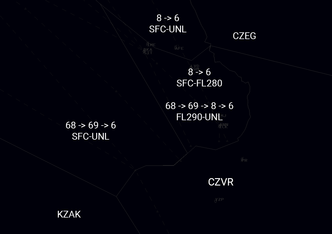
Attachment C - PAZA Enroute Sectorization #
The following figure is the visual representation of the south eastern boundary of the PAZA airspace.
-
Areas
- The above diagram depicts all the possible splits. Day to day operations will generally be ANC_06_CTR. During high traffic, Sector 8 or High Area will be split. The first split for High Area will be 69, and if traffic to the south is high sector 68 can be split off from that.
- In the above diagram, the left-most sector ID is the primary “owner”, but is consolidated as needed moving right. IE, with “68 -> 69 -> 6” if 68 is not staffed, it’s owned by 69, where if 69 is not staffed it is owned by 6
Area Name Primary Sector Callsign Radio Callsign Frequency (VHF) South** ANC_06_CTR Anchorage Center 132.3 South ANC_08_CTR Anchorage Center 126.1 High ANC_69_CTR Anchorage Center 133.8 High ANC_68_CTR Anchorage Center 127.3 -
Sector designations:
- The line separating 8 and 68 from the south border is drawn:
N054.24.30.300 W133.16.26.000 N058.00.00.000 W137.50.00.000
- The line separating 8 and 68 from the south border is drawn:
* Positions combine to this area
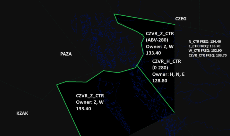
Attachment D - CZVR Enroute Coordination #
The following diagram is a visual representation of the western shared border of CZVR and PAZA:
-
Areas:
- The above diagram depicts all the possible splits. Day to day operations will generally see a combined CZVR_CTR or CZVR_1_CTR (relief callsign) that combines both sectors.
- In the above diagram, the leftmost sector ID next to the “owner” label is the primary “owner”, but is consolidated as needed moving right. IE, with “H -> N -> E” if H is not staffed, it’s owned by N, where if N is not staffed it is owned by E. If there are no splits online it is simply owned by CZVR_CTR (or CZVR_1_CTR)
Area Name Primary Sector Callsign Radio Callsign Frequency Sandspit CZVR_Z_CTR Vancouver Center 133.4 Haida CZVR_H_CTR Vancouver Center 128.8 North CZVR_N_CTR Vancouver Center 134.4 West CZVR_W_CTR Vancouver Center 132.9 East CZVR_E_CTR Vancouver Center 133.7 East (Combined) CZVR_CTR Vancouver Center 133.7 East (Combined) CZVR_1_CTR Vancouver Center 133.7 -
Sector designations:
- The point separating CZVR_Z_CTR from CZVR_H_CTR is drawn at:
N054.48.59.637 W130.30.00.605 N052.48.28.735 W127.53.00.774
- The point separating CZVR_Z_CTR from CZVR_H_CTR is drawn at: